
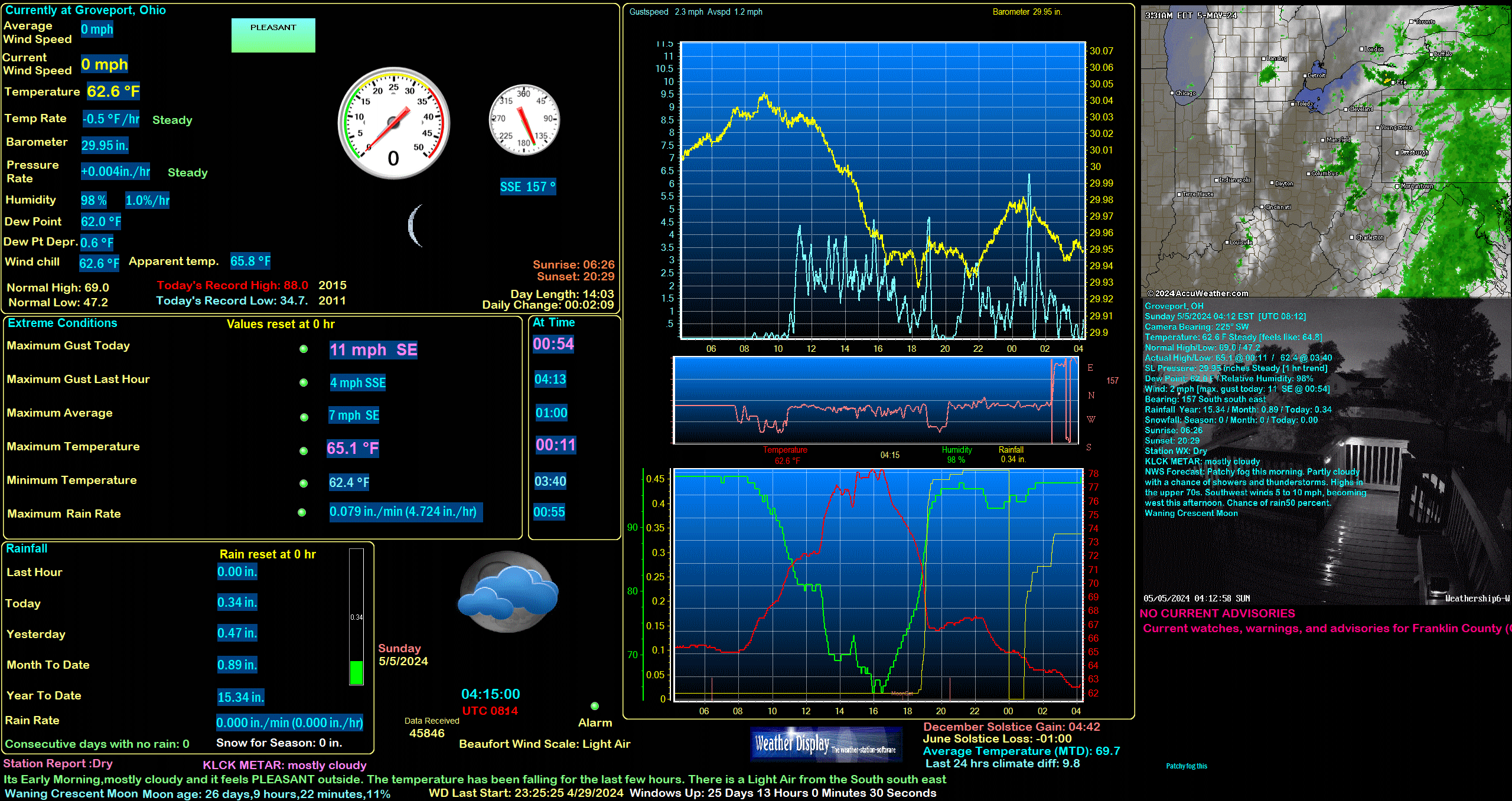
OHC049
Current watches, warnings, and advisories for Franklin County (OHC049) OH


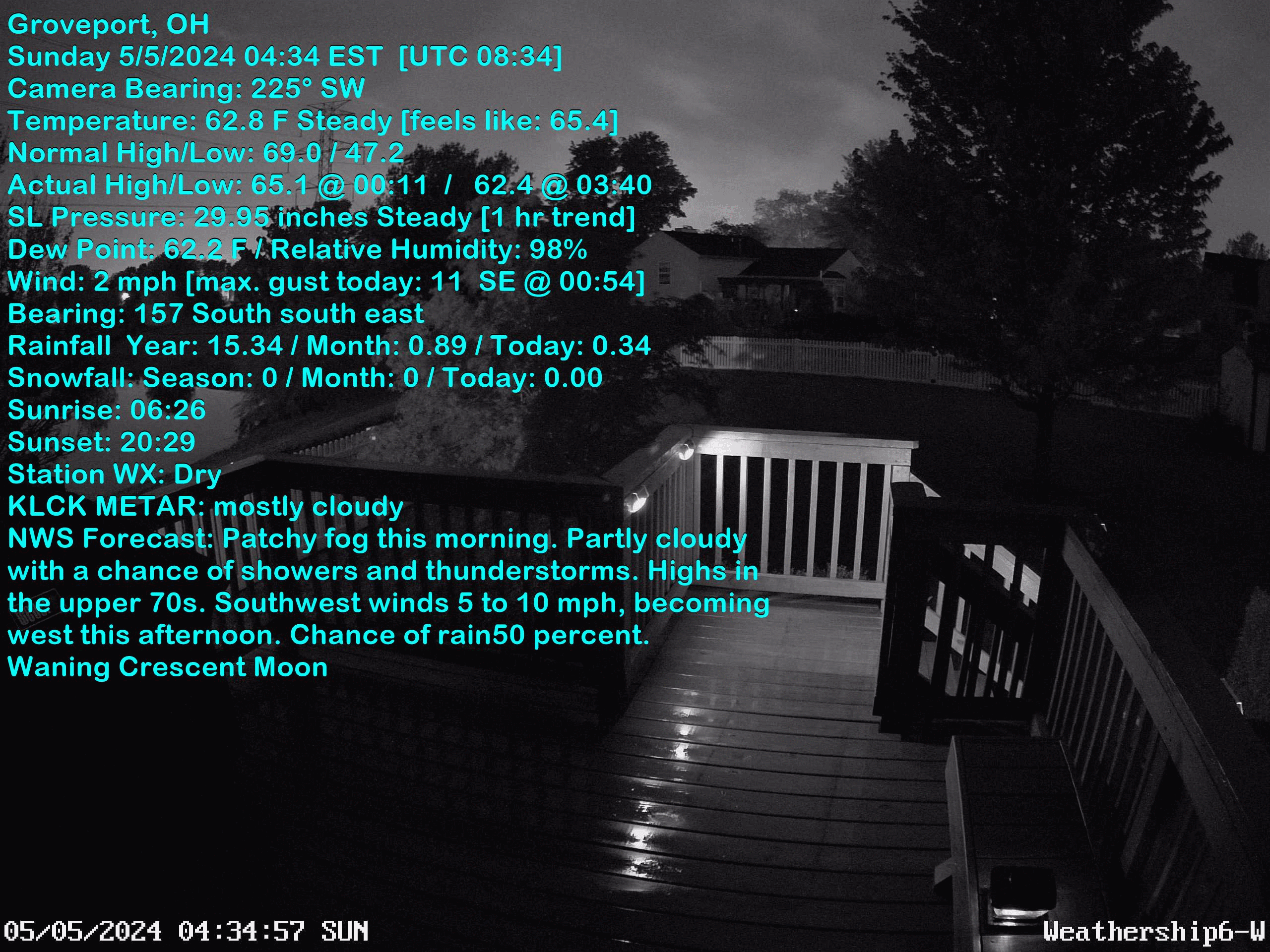
| Groveport, OH Weather | |||
|---|---|---|---|
| LAST READING AT TIME: 13:30 DATE: May 10 2024, time of next update: 13:35 | |||
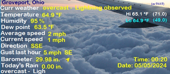
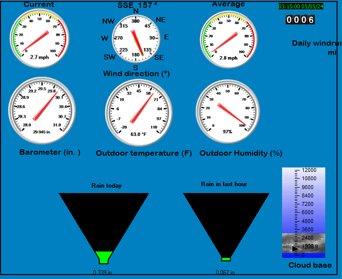
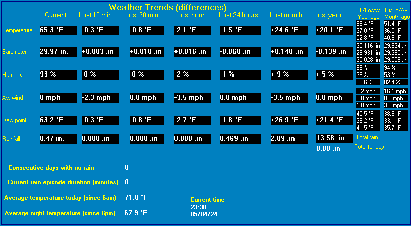
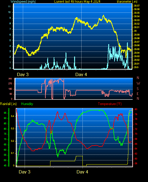
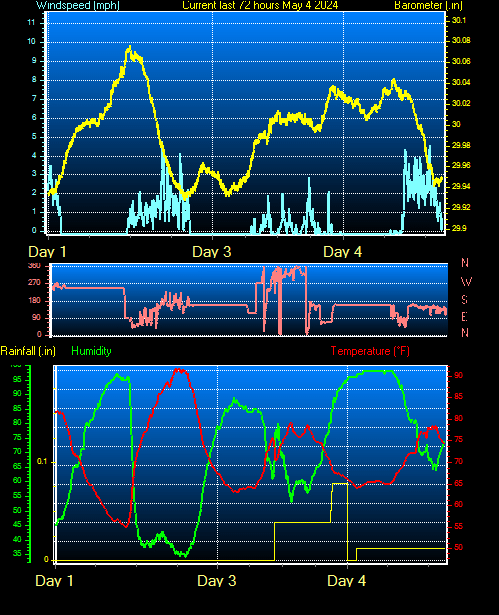
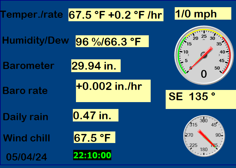
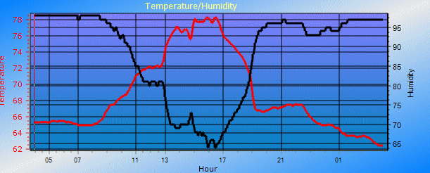
| Current Weather | partly cloudy | Current Temperature | 66.9°F (19.4°C) (Heat Index 66.9°F ), Apparent temp 66.3°F |
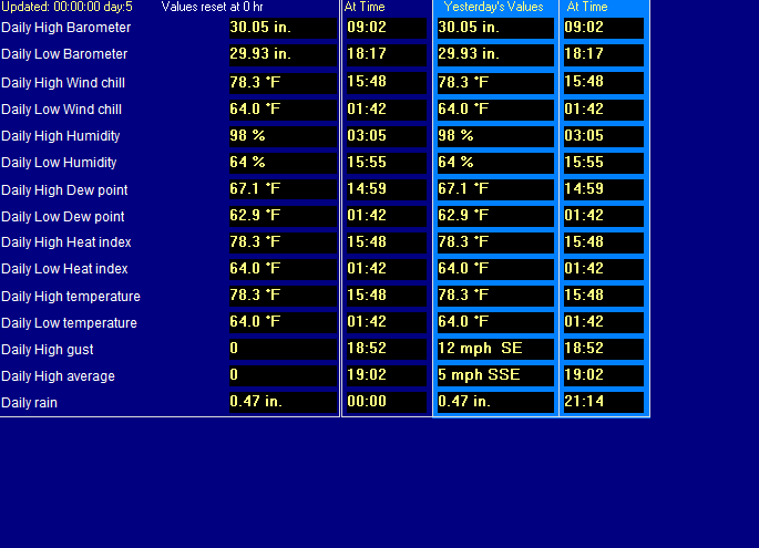
| Maximum Temperature (since midnight) | 68.0°F at: 13:02 | Minimum Temperature (since midnight) | 50.7°F at: 04:26 |
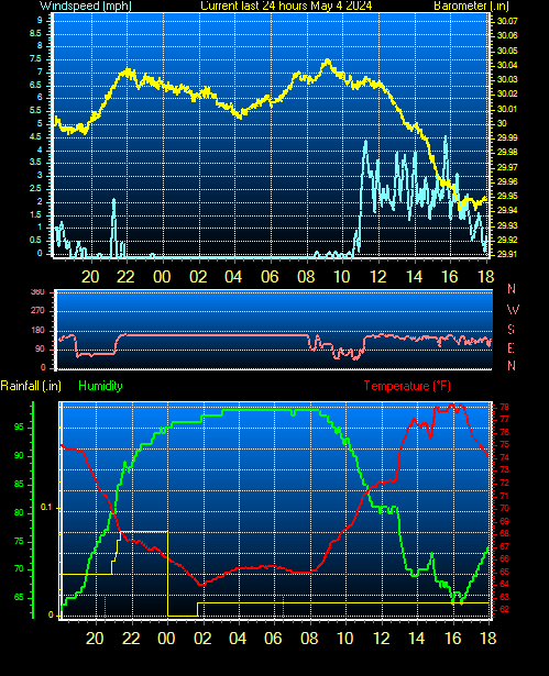
| Average windspeed (ten minute) | 2.1 mph | Wind Direction (ten minute) | NNW (340°) |
| Windchill Temperature | 66.9°F | Maximum Gust (last hour) | 9.6 mph at: 13:08 |
| Maximum Gust (since midnight) | 10.4 mph at: 16:00 | Maximum 1 minute average (since midnight) | 3.2 mph at: 12:32 |
| Rainfall (last hour) | 0.00 in. (0.0 mm) | Rainfall (since midnight) | 0.05 in. (1.3 mm) at 06:41 |
| Rainfall This month | 1.87 in. (47.5 mm) | Rainfall To date this year | 16.33 in. (414.7 mm) |
| Maximum rain per minute (last hour) | 0.00 in/min | Maximum rain per hour (last 6 hours) | 0.00 in/hour |
| Yesterdays rainfall | 0.22 in | DewPoint | 48.7°F (Wet Bulb :57.2°F ) |
| Humidity | 52 %, Humidex 68.6°F | Barometer corrected to msl | 29.88 in. (1011.8 hPa) |
| Pressure change | 0.00 in. (last hour) | Trend (last hour) | STEADY |
| Pressure change (last 12 hours) | +0.08 in | Pressure change (last 6 hours) | +0.04 in |
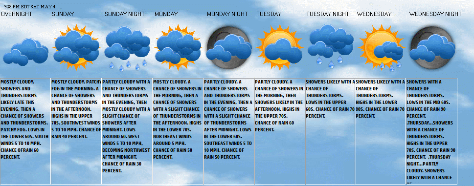
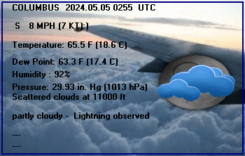
Expires:202405102100;;974777
FPUS51 KILN 101617
ZFPILN

Zone Forecast Product
National Weather Service Wilmington OH
1216 PM EDT Fri May 10 2024


OHZ055-102100-
Franklin-
Including the city of Downtown Columbus
1216 PM EDT Fri May 10 2024

.THIS AFTERNOON...Mostly sunny. Highs in the mid 60s. North winds
10 to 15 mph.
.TONIGHT...Mostly clear. Lows in the upper 40s. Northwest winds
5 to 10 mph, becoming southwest after midnight.
.SATURDAY...Showers with a slight chance of thunderstorms in the
morning, then partly cloudy with a chance of showers with a
slight chance of thunderstorms in the afternoon. Highs in the
upper 60s. Southwest winds 10 to 15 mph, becoming west in the
afternoon. Chance of rain 100 percent.
.SATURDAY NIGHT...Mostly clear. A chance of showers in the
evening. Lows in the mid 40s. Northwest winds 10 to 15 mph with
gusts up to 25 mph. Chance of rain 30 percent.
.SUNDAY...Sunny. Highs around 70. Northwest winds 5 to 10 mph.
.SUNDAY NIGHT...Mostly clear. Lows in the lower 50s.
.MONDAY...Partly cloudy. Highs in the upper 70s.
.MONDAY NIGHT...Partly cloudy with a chance of showers in the
evening, then mostly cloudy with showers likely after midnight.
Lows in the upper 50s. Chance of rain 60 percent.
.TUESDAY...Showers likely in the morning, then showers likely
with a chance of thunderstorms in the afternoon. Highs in the
lower 70s. Chance of rain 70 percent.
.TUESDAY NIGHT...Partly cloudy. Showers likely with a chance of
thunderstorms in the evening, then a chance of showers and
thunderstorms after midnight. Lows in the mid 50s. Chance of rain
70 percent.
.WEDNESDAY...Partly cloudy. A chance of showers. Highs in the mid
70s. Chance of rain 40 percent.
.WEDNESDAY NIGHT...Partly cloudy. A chance of showers in the
evening. Lows in the mid 50s. Chance of rain 40 percent.
.THURSDAY...Partly cloudy. A chance of showers in the afternoon.
Highs in the upper 70s. Chance of rain 40 percent.

$$


Expires:202405102200;;975593
FPUS51 KBUF 101649
ZFPBUF

Zone Forecasts for Western New York
National Weather Service Buffalo NY
1249 PM EDT Fri May 10 2024


NYZ003-102200-
Monroe-
Including the city of Rochester
1249 PM EDT Fri May 10 2024

.THIS AFTERNOON...Mostly cloudy. A little light rain...mainly east of
Rochester. Cool with highs in the mid 50s. Northeast winds 10 mph or
less. Chance of rain 90 percent.
.TONIGHT...Mostly cloudy. A chance of showers in the evening. Lows
in the mid 40s. Light winds. Chance of rain 40 percent.
.SATURDAY...Partly sunny with a chance of showers in the morning,
then cloudy with showers likely with a chance of thunderstorms in
the afternoon. Highs around 60. Light winds. Chance of rain
70 percent.
.SATURDAY NIGHT...Cloudy. Showers likely with a chance of
thunderstorms in the evening, then a chance of showers overnight.
Lows in the upper 40s. Light winds. Chance of rain 70 percent.
.SUNDAY...Mostly cloudy with a chance of showers in the morning,
then partly sunny in the afternoon. Highs in the lower 60s.
Northwest winds 10 mph or less. Chance of rain 40 percent.
.SUNDAY NIGHT...Partly cloudy. Lows in the upper 40s.
.MONDAY...Showers likely. Highs in the upper 60s. Chance of rain
60 percent.
.MONDAY NIGHT...Showers likely. Lows in the lower 50s. Chance of
rain 60 percent.
.TUESDAY...Partly sunny with a 50 percent chance of showers. Highs
in the mid 60s.
.TUESDAY NIGHT...Mostly cloudy with a 40 percent chance of showers.
Lows around 50.
.WEDNESDAY...Partly sunny with a 30 percent chance of showers. Highs
in the mid 60s.
.WEDNESDAY NIGHT...Partly cloudy with a 30 percent chance of
showers. Lows in the upper 40s.
.THURSDAY...Mostly sunny. Highs in the upper 60s.

$$


Expires:202405102200;;975583
FPUS51 KBUF 101649
ZFPBUF

Zone Forecasts for Western New York
National Weather Service Buffalo NY
1249 PM EDT Fri May 10 2024


NYZ010-102200-
Northern Erie-
Including the city of Buffalo
1249 PM EDT Fri May 10 2024

.THIS AFTERNOON...Mostly cloudy with a 50 percent chance of showers.
Highs in the upper 50s. Light northeast winds.
.TONIGHT...Partly to mostly cloudy. Lows in the lower 40s. Light
south winds.
.SATURDAY...Partly sunny with a chance of showers in the morning,
then cloudy with showers likely with a chance of thunderstorms in
the afternoon. Highs in the lower 60s. Light winds, becoming
southwest around 10 mph. Chance of rain 70 percent.
.SATURDAY NIGHT...Mostly cloudy. Showers likely with a chance of
thunderstorms in the evening, then a chance of showers overnight.
Lows in the upper 40s. South winds around 10 mph, becoming light.
Chance of rain 70 percent.
.SUNDAY...Mostly cloudy with a chance of showers in the morning,
then partly sunny in the afternoon. Highs in the lower 60s. Light
winds, becoming northwest around 10 mph. Chance of rain 30 percent.
.SUNDAY NIGHT...Partly cloudy with a 30 percent chance of showers.
Lows in the upper 40s.
.MONDAY...Showers likely. Highs in the upper 60s. Chance of rain
60 percent.
.MONDAY NIGHT...Showers likely. Lows in the lower 50s. Chance of
rain 60 percent.
.TUESDAY...Partly sunny with a 50 percent chance of showers. Highs
in the mid 60s.
.TUESDAY NIGHT...Mostly cloudy with a 40 percent chance of showers.
Lows around 50.
.WEDNESDAY...Partly sunny with a 30 percent chance of showers. Highs
in the upper 60s.
.WEDNESDAY NIGHT...Partly cloudy with a 30 percent chance of
showers. Lows in the upper 40s.
.THURSDAY...Mostly sunny. Highs in the lower 70s.

$$


PORT COLUMBUS INTERNATIONAL  AIRPORT, OH, United States (KCMH) 40-00N 82-53W 247M
May 10, 2024 - 12:51 PM EDT / 2024.05.10 1651 UTC
Wind: from the NNW (330 degrees) at 13 MPH (11 KT) gusting to 21 MPH (18 KT):0
Visibility: 10 mile(s):0
Sky conditions: partly cloudy
Temperature: 63.0 F (17.2 C)
Dew Point: 45.0 F (7.2 C)
Relative Humidity: 51%
Pressure (altimeter): 29.84 in. Hg (1010 hPa)
ob: KCMH 101651Z 33011G18KT 10SM SCT039 SCT048 17/07 A2984 RMK AO2 SLP101 T01720072
cycle: 17
BOSTON LOGAN INTERNATIONAL, MA, United States (KBOS) 42-22N 071-01W 54M
May 10, 2024 - 12:54 PM EDT / 2024.05.10 1654 UTC
Wind: from the E (090 degrees) at 14 MPH (12 KT):0
Visibility: 10 mile(s):0
Sky conditions: partly cloudy
Temperature: 53.1 F (11.7 C)
Dew Point: 37.9 F (3.3 C)
Relative Humidity: 56%
Pressure (altimeter): 29.83 in. Hg (1010 hPa)
ob: KBOS 101654Z 09012KT 10SM FEW030 FEW150 FEW200 SCT250 12/03 A2983 RMK AO2 SLP101 T01170033
cycle: 17
GREATER BUFFALO INTERNATIONAL  AIRPORT , NY, United States (KBUF) 42-56N 078-44W 225M
May 10, 2024 - 12:54 PM EDT / 2024.05.10 1654 UTC
Wind: from the ENE (070 degrees) at 5 MPH (4 KT):0
Visibility: 10 mile(s):0
Sky conditions: mostly cloudy
Temperature: 60.1 F (15.6 C)
Dew Point: 43.0 F (6.1 C)
Relative Humidity: 53%
Pressure (altimeter): 29.8 in. Hg (1009 hPa)
ob: KBUF 101654Z 07004KT 10SM SCT032 SCT080 BKN130 BKN220 BKN270 16/06 A2980 RMK AO2 SLP090 T01560061
cycle: 17
GREATER ROCHESTER INTERNATIONAL , NY, United States (KROC) 43-07N 077-41W 178M
May 10, 2024 - 12:54 PM EDT / 2024.05.10 1654 UTC
Wind: from the NNE (020 degrees) at 8 MPH (7 KT):0
Visibility: 10 mile(s):0
Sky conditions: overcast
Temperature: 57.9 F (14.4 C)
Dew Point: 46.9 F (8.3 C)
Relative Humidity: 66%
Pressure (altimeter): 29.81 in. Hg (1009 hPa)
ob: KROC 101654Z 02007KT 10SM FEW023 SCT040 OVC160 14/08 A2981 RMK AO2 SLP098 T01440083
cycle: 17
HYANNIS BARNSTABLE BOARDMN, MA, United States (KHYA) 41-40N 070-16W 22M
May 10, 2024 - 12:56 PM EDT / 2024.05.10 1656 UTC
Wind: from the NNE (030 degrees) at 14 MPH (12 KT) gusting to 23 MPH (20 KT):0
Visibility: 10 mile(s):0
Sky conditions: overcast
Temperature: 53.1 F (11.7 C)
Dew Point: 39.0 F (3.9 C)
Relative Humidity: 58%
Pressure (altimeter): 29.78 in. Hg (1008 hPa)
ob: KHYA 101656Z 03012G20KT 10SM OVC095 12/04 A2978 RMK AO2 SLP084 T01170039
cycle: 17
Rickenbacker Air National Guard Base, OH, United States (KLCK) 39-49N 082-56W
May 10, 2024 - 12:55 PM EDT / 2024.05.10 1655 UTC
Wind: from the N (350 degrees) at 14 MPH (12 KT):0
Visibility: 10 mile(s):0
Sky conditions: partly cloudy
Temperature: 64.4 F (18.0 C)
Dew Point: 45.7 F (7.6 C)
Relative Humidity: 50%
Pressure (altimeter): 29.84 in. Hg (1010 hPa)
ob: KLCK 101655Z AUTO 35012KT 10SM SCT047 18/08 A2984 RMK AO2 T01800076
cycle: 17
Use the RELOAD facility on your browser to retrieve the latest data.